The area
Zacharo Beach

The beach in Zacharo
For everyone who has ever been to Zacharo even once, the first thing that crosses their mind regarding the town is its sea. On the cove of Kyparissian Gulf, it is part of the “endless” coastline of Ilia Prefecture facing Ionion Sea, and the word endless is no exaggeration: while in most places a beach occupies no more than a few hundred meters, in Zacharo the beach literally extends as far as the eye can see. Of course, in the case of Zacharo the term “beach” is relative, as it is hard to say where one seaside stops and where the next one begins, because of the vast seashore.
Since the institution of the Blue Flag, Zacharo is awarded this honour every year. Not without a reason, it is considered one of the best known beaches in Greece, thanks to its large extent, its clear deep blue waters and its golden sand. Every summer, lots of Greek and foreign tourists stream into it in order to enjoy the caress of the sun and swimming in the calm waters, while it is also suitable for water sports.
Another feature of Zacharo beach is that although quite famous, its visitors won’t be bothered by the hustle and bustle encountered in other places during summer. Therefore, they will be able to swim in the organized central beach (with its open bar, deck-chairs and sunshades) or in Kakovatos, which are the most popular, or choose one from those less crowded, such as Bishinokampos (near PALM Apartments), Neochori or Giannitsochori. Of course, there are also many secluded sites along the coastline for lovers of peacefulness and privacy. The big extent of the area guarantees that everybody will find in Zacharo a beach to their taste.
Kaiafas

The lake of Kaiafas, viewed from the side of the Baths. The islet of Saint Catherine can be seen at the centre, with the forest surrounding it.
The other reason for Zacharo’s great reputation is undoubtedly Kaiafas, an area 2 km north of the town, where the lake of the same name lies at the foot of Lapithas mountain. It is a place of rare beauty, with a unique combination of lake, mountain, forest and beach landscape.
According to tradition, the area of Kaiafas was named so after the infamous Christ’s judge, who was once travelling by sea and encountered a storm that forced him to anchor at the area. He washed in the waters of the near spring and since then they acquired their characteristic sulphur smell. An ancient myth attributes this smell to the centaur Nessos, when he washed there the wound caused by the poisonous arrow Hercules threw at him. However, the place most probably took its name from the nymph Kaliafeia who along with Pigaia and Iasis was supposed to be living in the cavern of the Anigrid nymphs, where the healing spring has its source.
The spring and its baths were known for their healing properties since antiquity. In fact, there were altars in the area, where the sick offered sacrifices to the nymphs asking for their cure. The use of the baths continues up to this day, since they are considered beneficial for muscular-sceletal, skin and respiratory diseases. The cavern of the nymphs has been suitably formed and operates as a hydropathic center, visited by many tourists every year. A second spring named Geranio is situated 200 metres away from it, with its water thought to be suitable for treating kidney and liver ailments.
The lake of Kaiafas was formed during the 6th century B.C. as a result of major earthquakes that caused soil landslides. With a length of 3 km and a 500-600 metres average width, it takes up a surface of approximately 375 acres. Fish, turtles and eels live in it, and it is also an intermediate stop for many species of migratory birds every winter. On the islet of Saint Catherine in the center of the lake lie the Greek Tourism Organization facilities and it’s the starting point for the small boat that offers a sightseeing tour around the lake.
During the summer, Kaiafas serves as a training ground for rowing and jet-ski teams, and also hosts events for these sports, starting with the All-European jet-ski Championship in 1997. Due to its ideal weather conditions (protected from winds, with minimal surface rippling and mild climate conditions, even in winter), the location is considered one of the most suitable in Europe for watersports.

The old tower in the beach of Kaiafas
Kaiafas is a magical place in which the uniqueness of the landscape is apparent wherever one turns his look at. The imposing mountain volume of Lapithas rises above it and one can walk on its slopes, following tracks used for centuries now. The lake itself is surrounded by the well known pineforest, which although hit by recent fires maintains its beauty and offers its visitors an indescribable feeling of tranquility and contact with nature as they walk in the shades of its trees.
The beauty of the place is not confined only to the lake, however. The visitors may continue their tour of the place by passing the National road that is only a few meters away form the islet, cross the railroad tracks and walk on the golden sand that forms dunes, stopping for rest under the clumps of pine trees. Following the rising inclination of the ground, they will walk past the old tower that served as a lookout post against pirate raids, will reach the last dune and then they will encounter a wonderful view: the vast beach of Kaiafas spreading in front of their eyes, that will win them with its simplicity and its free of human interference charm. It is imperative to stay in beach until the sunset, which is truly captivating with the changing of the sky’s colors and among the most beautiful ones in all Greece.
Neda
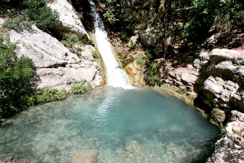
The visitors can refresh themselves by swimming in the natural ponds that are formed at the base of the waterfalls
Neda, the only river in Greece with a female name, is a natural border between the Ilia and Messinia prefectures. Its spring is on mount Lykeon on the mountainous part of Messinia and it flows for 32 km before it empties into the Ionion Sea, at the Elea location.
The river owes its name to Neda, who along with Thisoa and Agno were the nymphs to which (according to the Arcadian mythological tradition) the goddess Rea entrusted the raising of baby Zeus after he was born, in order to protect him from the fury of his father Cronus.
The river itself, as well as the ravine it crosses throughout most of its length, is an up to recently unexplored part of Greek nature and considered one of the virgin places in Greece, because the marks of human intervention in it are minimal and discrete. Anyone who has ever visited Neda can’t stay unaffected by the majestic beauty of its scenery: the ravine sides are full of aquatic vegetation, perennial planetrees and oaks stand imperiously over the clear light green waters of the river, and clumps of poplars, holm-oaks, wild hazel-, walnut- and cypress trees offer their shade to the visitors who want to rest, listening to the birds singing. The ravine is a refuge for otters, foxes, rare reptiles and birds, while butterflies and libellulas fly on the river shores. Imposing rocks rise in several spots and there are three waterfalls along the river.
Neda becomes accessible from May to September, when the level of its waters is lowered. It is then that many visitors go trekking in the ravine – the most daring ones cross Neda’s full length, an experience that offers great excitement but requires time, extreme caution and definitely sports equipment: besides walking under the bright sunlight, in many spots the current becomes strong, narrow fords impede the hike and elsewhere swimming is the only way of crossing. Of course, anytime someone wants to cool themselves they may dive in the river’s frozen waters or in one of the ponds that form at the basis of each waterfall.
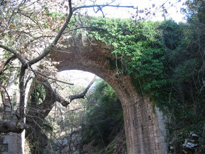
The stone bridge in Neda
There are various entrances to the ravine; the most popular is in the village Platania, where after descending from stairs carved on the rocks the visitors will come across a scenery of captivating beauty. This is the location of the first and most impressive of the Neda waterfalls with a 50 metres height, the small chapel of Virgin Mary which seems to spring out of the rock, while a little higher lies the cavity where according to the tradition Her wonder-working icon was discovered. Following the river flow, one passes below the stone bridge and comes to the second waterfall.
At this point it’s worth exploring Stomio (“Mouth”), a cavern run through by Neda waters, at around 600 metres after the stone bridge. Approximately 100 metres long, it is virtually a natural tunnel into which the river rushes, only to continue its course on the other side flowing into the Pamissos tributary. Inside Stomio, the visitors will be filled with awe by the eerie atmosphere with the stalactites, the lap of waters as they fall from high above, the bats and the wild pigeons that nest there, and they will have to swim in order to cross the cavern. Therefore, it is quite understandable why the ancient Greeks thought that Stomio was one of the entrances to Hades, the underworld.
Half an hour later, trekkers will come across the third waterfall, and after a while the ravine “opens up” and the river flows through prairies, orchards and crops, before it ends up in Ionion Sea.
Ai-Giannakis
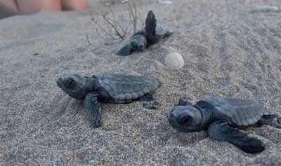
Newborn Caretta-Caretta turtles on their first trip from their nest to the sea.
Just 15 km south of PALM Apartments, in the borders of the Ilia and Messinia prefectures, lies the beach of Ai-Giannakis. It is a very beautiful place, with a large pine forest, sanddunes and (of course) crystal-clear blue waters. Yet it owes its reputation to the fact that it hosts the second most important egg-laying area of the Caretta Caretta sea turtle in the Mediterranean sea. This is by itself very important from an ecological point of view, because out of the 7 sea turtle species in the world only 3 can be found in the Mediterranean – and from those, only Caretta Caretta lays eggs in Greece.
This sandy beach of the south Kyparissian Gulf attracts the female turtles who are about to breed (male turtles return practically never to the shore). A turtle lays eggs every 2-4 years. Comes out in the sand, digs a nest where it lays 80-120 eggs (something that might be repeated 2 or 3 more times during the summer) and then goes back in the water, leaving them behind to hatch.
Two months later, the small turtles have hatched and leave their nests on a single night. Their instinct drives them to move by themselves, without the guidance of older members, towards the sea, which they find by the reflection of the stars and the moon on its surface. This procedure is very significant, because the memory of this first stroll allows the hatchlings to orientate in order to return to this same place when they come of age (because sea turtles always lay eggs on the very same beach where they were also born).
On the beach, the Archelon environmental society has set up a center for ecological awareness in the old train station building. In it there’s an exhibition to be found and all information pertaining the Caretta Caretta are provided. The building also contains a specially tailored space, where one may learn how a sea turtle is born and grows up. The volunteers of the Archelon society monitor the full extent of Ai-Giannakis beach and protect the nests.
Ancient Olympia
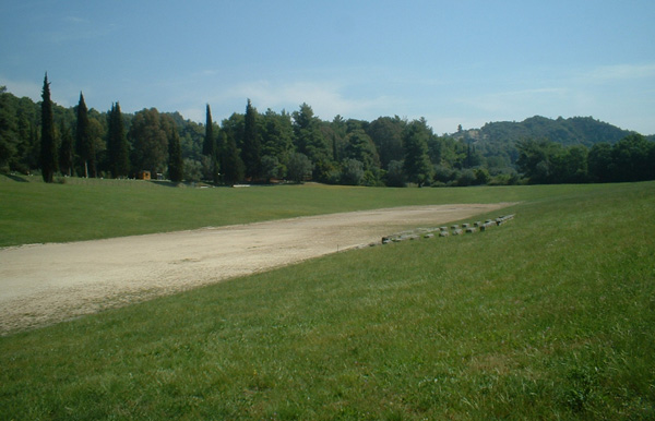
View of the Stadium in Ancient Olympia: the stand of the judges can be seen at the centre
On the west of Peloponnese, 25 km away from Zacharo, lies one of the most renowned places of the whole world, a site that is justifiably considered one of the birthplaces of modern civilization, ancient Olympia. It was the biggest religious centre of ancient Greece (along with Delphi), dedicated to the worship of the god Zeus, but its reputation is mainly attributed to the fact that it was the birthplace of the Olympic Games.
There are many myths regarding the establishment of the Olympic Games. Most likely the first Games (“Olympiad”) were held in 776 B.C. as a result of a peace treaty between Ilia and Sparta. Whatever the truth, however, what matters is that Olympia, a small town in a rather isolated area of the Greek world, became the center of the known world every 4 years: thousands of people flocked to attend the Games which attracted the elite of athletes from all over Greece. Non Greeks were also allowed to attend the games, but merely as spectators and with no right to participate as athletes.
Indicative of the Games’ prestige is the fact that for their duration a truce prevailed between any Greek cities that were at war (which was respected by all) and also that the dating of the years for all Greek city-states was according to the Olympiads.
Olympia was at the pinnacle of its thriving in the 4th century B.C. – it was the time that an extensive construction activity took place, so as to improve the facilities and the creation of accommodation for the constantly increasing number of visitors and athletes. Even though later on the Games lost their religious significance and turned into mere sport events, the architectural development of the Sanctuary was continued during the Hellenistic and the Roman years. The remains of many of these buildings are preserved up to now: their excavation was first conducted by French archeologists, then it went on by the German Archeological Institute of Athens up to today. Their most recent project involves the discovery of the location of Olympia’s Hippodrome.
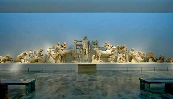
Museum of Ancient Olympia: the western pediment of Zeus Temple
The Sanctuary of Olympia stretches at the southern foot of Cronion hill, between the confluence of the Alfeos and Kladeos rivers. In ancient times, the valley enclosed by the two rivers was full of wild olive, poplar, oak, pine and plane trees, and that’s why the Sanctuary was named Altis, meaning “grove”. Altis is surrounded by an enclosure, inside which lie the main religious buildings and voting offerings, while outside of it the auxiliary buildings (the priests’ dwellings, the baths and the training facilities for the athletes) and the guest rooms are to be found.
The modern visitors have the chance to walk on the archeological Site of Olympia and feel centuries of history surrounding them, any place they cast their look at. A visit to the Stadium is imperative: according to the myth, its length was determined by Hercules himself at 212,45m (600 times the size of his foot). After crossing the Echo portico, named after its perfect acoustics, and through the entrance to the Stadium, they will enter the place where the Olympic Games were held and being attended by approximately 45.000 spectators.
The monuments one can admire in Ancient Olympia include:
- the Temple of Zeus, the most imposing and in the most prominent position building of the Altis (with dimensions 64,12 x 27,68 and 20,25 m high). The gold and ivory statue of Zeus, one of the seven wonders of the antiquity, was in its interior.
- the Temple of Hera. The statue of Hermes of Praxiteles was discovered there, while the Olympic flame was being lit every four years on the teple's altar .
- the Gymnasium, where the athletes trained for sports that required substantial space - discus and javelin throwing, and track sports.
- the Palaestre, the training ground for wrestling, boxing and long jump.
- Phedia's workshop.
- the Philippeion, built by Philip the Macedon, after the battle of Cheronea.
- the Leonidaion, used for the hospitality of the officials.
- the Zannes (plural for the name "Zeus"), 16 bases for copper statues of the god, erected from the fines paid by those that had broken the Games' regulations and served as a warning.
In the Museum of Ancient Olympia, right opposite the archeological site, the visitors may find a detailed reconstruction of the Sanctuary and its surroundings during its peak years, as well as plenty of impressive exhibits: among them, the Hermes of Praxiteles, the Nike of Paionios, the Zeus and Ganymedes statuette, statues from the pediments and the metopes of Zeus Temple and the Helmet of Miltiades. There is also a multitude of pottery, statuettes, jewellery, objects used by the athletes, etc.
Epikourios Apollo
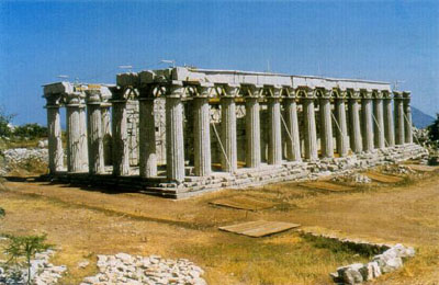
The temple of Epikourios Apollo in Vassai, before the placement of the maintenance shelter.
The temple of Epikourios Apollo is situated in Vassai, 45 km from PALM Apartments, at an altitude of 1.130 m. Dedicated to the god Apollo by the inhabitants of Ancient Figalia (Epikourios Apollo = “Apollo the Helper”), as a thanks for relieving them from a plague epidemic, it dominates on Kotilio, part of the Lykeon massif, holy ground of the ancient Arcadians.
It is one of the most impressive temples of classical antiquity, preserved in a very good condition. It was the first Greek monument to be included in UNESCO’s World Heritage Sites in 1986 (one year before even Parthenon did). Built around 420-400 B.C., is attributed by the ancient sight historian Pausanias to Iktinos, one of Parthenon’s two architects.
Built on the site of a previous archaic temple, it combines elements of the archaic and the classical style in a unique way. It is of Doric technique, surrounded by columns (“peripteros”), with dimensions of 14.48 x 38.24 m, but in reality all three architectural order coexist in this temple: Ionian, Doric and Corinthian. It is characteristic that its colonnade bore the first recorded Corinthian capital in the history of architecture. The temple has a special exposure (North to South) which seems to have been dictated by the local worshiping traditions, while the column ratio 6x15 (instead of 6x13 that was the standard at the time) follows the pattern of the Apollo temple in Delphi.
Its frieze, displayed in the British Museum since 1814, was 31m long and went round all four sides. It is decorated with scenes of Amazon (Amazons - Athenians) and Centaur battles (Centaurs - Lapithians). The sculptor of the frieze might have been Paeonios, creator of the Nike famous statue in Olympia.
The temple is constructed from limestone found in the area. Because of its exposure to the region’s special climate conditions, the unstable soil and the human interference during the centuries, today the temple is covered by a plastic shelter, which will remain in place until the monument’s restoration works have been completed.
Ancient Samia
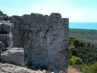
The stone wall of ancient Samia
In the north of Kaiafas lake stretches the archeological site of Kato Samiko, most likely identified as an ancient city that successively got the names Makistos, Arini and at the end Samia. Its location is of strategical importance, as it dominates the fertile valley of Samiko and the road that in ancient years used to connect the northwestern Peloponnese with Ilian Trifylia and Western Messinia, therefore it was later named “Kleidi” (meaning “Key”) by the locals. According to the tradition, the city was built in pre-Homeric years by Nileas, father of Nestor, king of Pylos. It was the center of the first federation of cities, the Minyan Hexapolis (Six-city area), a member of which was also the “well-built Aipi” that Homer reports to have taken part in the Trojan war.
The archeological site includes a prehistoric and a classical citadel. The prehistoric one lies on the rocky hill of Kleidi, at an altitude of 180 m. It is surrounded by cyclopean walls, which came to light in 1908. Newer excavations in 1954 revealed a tomb with graves, in which Mesohellenic and Mycenaean pots were discovered, while 5 more tombs (one of which was vaulted) were the result of digs in the 80’s, a fact that is considered to show that their Mycenaean creators belonged to the same nation as Mesohellenes.
In the classical citadel, on the western side of mount Lapithas, a strong wall 1500 m long and shaped as an irregular trapezium is preserved. It has 4 gates and large keeps on the exterior side, up to 5 m in height. Inside the wall lie the remains of many buildings; recently an edifice of large proportions, oblong, supported by columns and possibly serving a public purpose was discovered.
The god Poseidon was worshiped in the area. A sacred grove was there in his honour, the samian Poseidion. Most likely that was the reason why the ancient geographer Strabo considered Samia to be Nestor’s Pylos: he assumed it was in this coast that (according to Homer’s Odyssey) Telemachus disembarked while looking for information about his father’s Odysseus long absence from Ithaca, and he found the inhabitants of Pylos sacrificing pitch-black bulls in Poseidon’s sanctuary.
Ancient Lepreo

The temple of the goddess Demeter in Lepreo: plan view
The Ancient Lepreo was a city of southern Elian Trifylia, on the west elevations of Mount Minthi, over today’s community with the same name. According to the historian Herodotus, Lepreo was a member of the aforementioned Minyan Hexapolis, founded on this area where the Kafkones people used to live before. The mythical founder of the city is considered to be Lepreos, son of Pyrgeas, who was challenged to a triple competition by Hercules: to throw the discus, drink water with the buckets and eat a whole ox each. The hero won the 2 first trials, while Lepreos won the third one. Then, intoxicated by his victory, he challenged Hercules to a duel, where he was finally killed.
The city dated from prehistoric up to the byzantine times, and it thrived especially during the classical and Hellenistic period, when it even became the capital of Trifylia. Lepreo was a prosper land, according to Strabo, as it controlled the area’s most fertile valley, the “Epasion Pedion”, was near the sea and the Neda river (which was navigable at the time) and the surrounding mountains ensured it had a mild climate.
Lepreo seems to have been inhabited since the Neolithic age. The prehistoric settlement, whose citadel in a naturally fortified position has been excavated, took advantage of the region’s natural resources and even had trade dealings with the Aegean sea. Buildings extending to 5000 sq.m. were discovered, as well as the remains of a paved street.
The citadel of the classical and hellenistic area occupies an elevation to the north of today’s village, with an impressive view of the Kyparissian Gulf. Its fortification is preserved in a very good condition and is evidence of the city’s prosperity during that time. It was carefully planned, equipped with square keeps. In the citadel’s interior lie the remains of buildings, a large altar and the classical temple attributed to the goddess Demeter, as Pausanias mentions.
Lepreo had a leading role among the cities of ancient Trifylia, since it controlled the roads connecting Ilia, Messinia and Arcadia. It was the main resisting force against the pressure from all its neighbours: the Messinians, Arcadians and especially the Ilians, against which the Lepreates (the inhabitants of Lepreo) proved to be the fiercest opponents. The claim on Lepreo by the Ilians, led the latter in an open collision with the Spartans, who invaded and sacked Ilia at the end of 500 B.C. 200 Lepreates fought in the battle of Plataies against the Persians and their names were carved on Zeus’ statue in Olympia, as well as on the tripod the victorious Greek cities dedicated to Apollo in Delphi to commemorate their victory.
Although declined, the city of Lepreo existed at least until 170 A.D - the last recorded testimony for it provided by Pausanias. It also appears to have survived up to the byzantine era, and the prevalent theory is that it was ravaged after pirate and barbarian raids in 800-1000 A.D.